


 COUNTRY MAPS
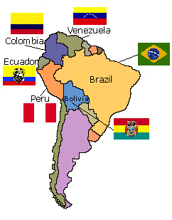
Maps of different countries enable us to study a particular country more closely. They may be used to represent territorial limits, natural resources, transportation routes, or any number of different kinds of information. Most modern country maps are for either governemnt or tourist purposes, as scientific maps do not usually concern specific countries. Governments use maps to assess resources, for planning development or tracking land use, whether for farming, urban use or for transportation. Tourist agencies want to show the highlights of a country, such as places to visit, national parks and how to get around. The map below shows the territories and national flags of the six main countries that claim part of the Amazon basin. |
Use the clickable map below to get the maps for the country you are interested in.
(Sorry, maps for Venezuela or Bolivia are not yet available.)
Click below to see the country maps image and information:

 Brazil

 Colombia

 Ecuador

 Peru
Peru

