What lies beneath the deep blue sea? The bottom of the ocean is today the world#39;s least known habitat.
With modern instruments scientists use sonar (sound waves) and radar (radio waves) to make
accurate maps of the sea floor. Before this advance, the sea floor was believed to be uniformly flat. Now we
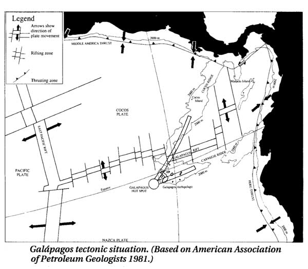
know it is a complicated mix of mountain chains, valleys, plains and isolated peaks. This map of the seafloor
around the Galapagos Islands shows the islands are a small group of mountains at the end of an undersea
chain—the Cocos Ridge. They lie near the boundary of two tectonic plates — giant rafts of rock floating
on the earth#39;s molten interior. The Nazca Plate stretches down the coast of South America and is moving
south. To its west, the South American continent is moving over it, causing the Nazca plate to slide
underneath—a process called subduction. To the north the Cocos Plate is moving toward Central America. The
Galapagos Rift is where the two plates meet and forms an area where new material comes to the surface of the
ocean floor. This is the force that drives the two plates apart—a process called seafloor
spreading. The Galapagos themselves are caused by an anomalous feature called a hotspot. This is a
an area of rising heat that burns a hole in the plate, causing molten rock to spill out—an underwater
volcano. When the rock hits water, it cools and solidifies. Eventually, enough rock can pile up to reach the
ocean#39;s surface, and a volcanic island is born. As the plate moves over the hotspot, new islands are formed,
the old volcanos become extinct and an island chain is formed. A similar process is believed to have created
the Hawaiian Islands.
(Map courtesy of Michael H. Jackson, Galapagos:
A Natural History Guide)
|


