KILIMANJARO SATELLITE IMAGES
Mount Kilimanjaro (Swahili meaning is 'shining mountain'), is the continent&s most famous mountain.
It is Africa&s highest point above sea level, rising to 19,340 feet. Being so high, it has a permanent ice cap of glaciers on its
southern and southwestern flanks, even though it is close to the equator. It is the only place in Africa where ice and snow persist year-round.
The ice cap has diminished significantly in recent years, most likely due to global warming. Scientists estimate that by 2015 the glaciers will no
longer exist. |
Click below to see the photos and information on satellite photos of Kilimanjaro:
directly overhead
composite side view
real color view
DIRECTLY OVERHEAD
Click image to return to gallery
This astonishing image of Kilimanjaro was taken February 2000 from the Landsat 7 satellite. The three main peaks of the mountain are to the right of the picture, whereas the complex of smaller volcanoes is evident to the west (left of picture). The prominent mountain to the center is Mount Meru. Arusha National Park (Tanzania) is visible to the south of Kilimanjaro, while Amboseli National Park (Kenya) protects the northern half. The colors result from computer enhancement of image data using shortwave infrared, infrared, and green wavelengths. |
COMPOSITE SIDE VIEW
Click image to return to gallery
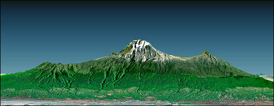
This dramatic image of Kilimanjaro was made from data acquired from the Shuttle Radar Topography Mission (SRTM and a Landsat 7 image (both in February 2000). The sky was added. This clearly shows the topography (shape and form) of the mountain, but the vertical scale has been expanded to twice its true height. The view represents a width across of 77 miles, from about 100 miles away. |
REAL COLOR VIEW
Click image to return to gallery
Mount Kilimanjaro (Tanzania) is the highest point in Africa, just under 20,000 feet. This image was taken from the Space Shuttle on mission STS-97 on December 2, 2000. The ice cap covers a much smaller area than merely ten years before the image above was taken. Compare this photo with an earlier image taken November 1990 by a Space Shuttle mission (STS-38). |


